In active tropics, there’s one system forecasters are telling the U.S. Gulf coast to watch closely
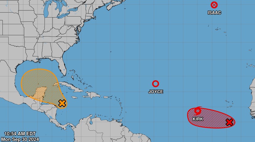
The tropics are very active as of Monday, with the National Hurricane Center watching five systems in the Atlantic Basin. That includes one that could become a major hurricane by Friday, and another that could enter the Gulf, much as Hurricane Helene did.
Forecasters are warning residents along the U.S. Gulf coast to watch the potential Gulf system closely.
It has a 40% chance of developing into a tropical system within a week, and that could happen in nearly the same area as Hurricane Helene formed a week ago — in the gap between Mexico’s Yucatan peninsula and the western tip of Cuba.
As of 11 a.m. Monday, it was moving generally to the northwest and would likely enter the Gulf of Mexico toward the end of the week. It’s too soon for forecasters to release a potential forecast track.
Far in the eastern Atlantic, Tropical Storm Kirk could become a “formidable” major hurricane by Friday, the National Hurricane Center said.
Kirk is located about 700 miles west of the Cabo Verde islands, has 45 mph winds and is moving west at 8 mph as of 11 a.m. Monday. By the end of the week it could be a major hurricane with wind speeds of 120 mph.
Long-range forecasts show the storm arcing north away from the Caribbean region, but forecasters warn that there’s low confidence in the long-range track projections.
Meanwhile, another disturbance off Africa could become a tropical depression, forecasters said Sunday. It has a 80% chance of developing in the next seven days.
As of 11 a.m. Monday, Isaac had weakened from a hurricane to a post-tropical cyclone. It was located about 515 miles north-northwest of the Azores with maximum sustained winds of 60 mph, moving east-northeast at 15 mph.
Forecasts for Hurricane Helene’s path were uncannily accurate. Here’s why.
Isaac should continue to weaken over the next several days.
Joyce, a system about 910 miles east-northeast of the Caribbean Sea, was downgraded to a tropical depression with sustained winds of 35 mph, moving very slowly northwest at 2 mph. The system poses no hazards to land.
Forecasters expect it to dissipate in the next two days.
Staff writer Robin Webb contributed to this report.


