Hurricane center tracks growing Caribbean system that could threaten Florida next week
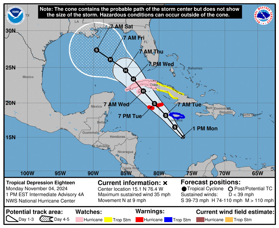
The National Hurricane Center said Tropical Depression 18 formed in the Caribbean on Monday, and is forecast to intensify into Tropical Storm Rafael and develop into a hurricane as it heads north toward the Gulf of Mexico.
As of the NHC’s 1 p.m. advisory, TD 18 was located about 200 miles south of Kingston, Jamaica and 430 miles southeast of Grand Cayman moving north at 9 mph with maximum sustained winds of 35 mph.
A hurricane warning is in effect for the Cayman Islands and tropical storm warning in place for Jamaica. A hurricane watch is in effect for the Cuban provinces of Pinar del Rio, Artemisa, La Habana, Mayabeque, Matanzas and the Isle of Youth.
“On the forecast track, the system is expected to move near Jamaica tonight, be near or over the Cayman Islands on Tuesday, and approach Cuba on Wednesday,” forecasters said. “Steady strengthening is forecast, and the depression is expected to become a tropical storm later today and a hurricane by Wednesday.”
Rainfall totals could reach more than 9 inches over Jamaica and Cuba through mid-week, and then spread north into Florida and adjacent areas of the southeast United States in the latter half of the week.
Forecast models have shifted more to the west since the weekend with the center of the storm entering the Gulf of Mexico still as a Category 1 hurricane, but losing steam before landfall likely along the Texas or Louisiana coast, although the western Florida panhandle remains within the cone of uncertainty.
“When the system reaches the Gulf of Mexico, the model solutions diverge, which appears to be due to differences in the steering patterns and vertical depth of the storm,” forecasters said in the official storm discussion. “The NHC track forecast is largely an update of the previous one and remains close to the various consensus models. However, it should be noted that the track forecast over the Gulf of Mexico is of low confidence.”
The National Weather Service in Miami forecasts more than 2 inches of rain on Tuesday evening for parts of South Florida with windy conditions. The NWS in Melbourne said 1-2 inches are likely Wednesday or Central Florida.
Because the system has yet to form a well-defined center, there is more uncertainty in the forecast track.
“Interests in the Florida Keys should closely monitor this system as tropical storm watches could be required for portions of these areas later today,” forecasters said. “The system is forecast to enter the Gulf of Mexico later this week, but given significant uncertainties in the long-range forecast track and intensity, it is too soon to determine what, if any, impacts could occur. Residents in this area should regularly monitor updates to the forecast.”
The tropical outlook as of 1 p.m. Monday, Nov. 5, 2024. (NHC)
The NHC also continued to track a potential system that could form north of the Caribbean’s Leeward Islands in a few days.
“Some slow development of this system is possible after that time as it moves generally westward over the southwestern Atlantic,” forecasters said.
The NHC gives it a 20% chance to develop in the next seven days.
And what had developed into Tropical Storm Patty lost its tropical characteristics as it continued its speedy path toward Spain in the far eastern Atlantic.
The NHC’s final 10 a.m. advisory Monday, the remnants of Patty were located about 585 miles east of the Azores moving east-northeast at 17 mph with maximum sustained winds of 35 mph.
It will still bring significant rainfall to parts of the Iberian peninsula with up to 5 inches in portions of Portugal and western Spain.
The 2024 Atlantic hurricane season has produced 16 named storms and now one tropical depression as well as on potential system that made landfall before developing. So far, 10 of the systems have grown into hurricanes, three of which have struck Florida’s Gulf Coast.
The official hurricane season runs through Nov. 30.


