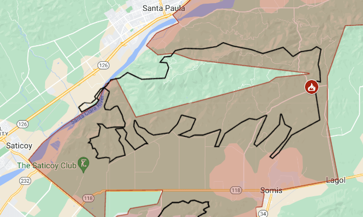
Map: Mountain Fire evacuations continue to expand in Ventura County
More evacuations have been ordered on the second day of the Mountain Fire, which has burned 14,000 acres in Ventura County.
Related Articles
25 million California residents face ‘life-threatening’ fire warning
Mountain Fire grows to 14,148 acres, burning homes and causing injuries, evacuations
Gusty Santa Ana winds bring high fire risk and power shutoffs across Southern California
Photos: Mountain Fire exploded to 10,457 acres in just over 5 hours
Power shut off for thousands of Bay Area customers during red flag warning weather
On Thursday morning, new evacuations were ordered for areas of Santa Paula and Bardsdale, along the Santa Clara River, and up to the west edge of Moorpark.
Ventura County Sheriff Jim Fryhoff, at a news conference Thursday morning, said the fire remained “very active … and unpredictable.” On its first day, the fire burned toward the west; on Thursday, the wind had changed direction, and firefighters’ focus was the northeast edge.
The Mountain Fire was reported shortly before 9 a.m. Wednesday, Nov. 6, during a red-flag warning that covered much of coastal California. The fire’s cause has not yet been determined, Ventura County Fire Chief Dustin Gardner said on Thursday.
The burned area was estimated at 14,182 acres (22 square miles) with 0% containment, according to the Ventura County Fire Department.
On Thursday morning, evacuations covered more than 80 square miles — the area shown in red on the map above — including some neighborhoods in Camarillo. The black line indicates the approximate fire perimeter. For updates on evacuation orders, see the Ventura County emergency website.
Teams were in the field to assess homes and other structures that have been destroyed or damaged. No figures were released at Thursday morning’s news conference.
Fixed-wing aircraft could not be used in the first day’s firefighting because of high winds, but they were in use on Thursday.
A National Weather Service spokesman said maximum gusts Thursday morning in the Ventura area were around 35 mph; on Wednesday, they had reached 80 mph. Winds were expected to diminish further in the late afternoon, and the red-flag warning — indicating heightened fire risk — was set to expire at 6 p.m.
Another round of high Santa Ana winds is forecast for next week in the Ventura County area, the weather service said.
The Mountain Fire is just south of the area of the Thomas Fire, which started in December 2017 and burned 281,893 acres, destroying more than 1,000 structures.


